Sunday morning I read a post on WildernessDave’s blog that delved into how diffident you can feel when you’ve decided to host a group hike but haven’t yet explored the trail you’re going to be hiking.
As Dave recounts:
We got an early start on a cold morning just as the sun was coming up. I may not have made it entirely clear from the beginning, but I had never hiked this trail before. I was going off of a pretty decent map and a trail description found online. I didn’t know if there would be trail markers or not, or how easy the trail would be to follow once we got out of Spur Cross Recreation Area. There is an expectation, when hiking with the person who has suggested the trail, that they are leading the hike. This dawned on me shortly after we got started and I felt the pressure of needing to know where we were, where we were going and how far we still needed to go. Every time someone asked, “is this the trail?” or “do we cross the creek here?” I felt like I should not only know the answer but be confident about it.
I appreciate Dave’s frankness in spite of what we may suppose are his ideal notions of himself; he encapsulates his experience well. I’ve certainly experienced the emotional struggle he was feeling; after all, every new trail is one you haven’t walked before. But when you’ve got other people joining you who may be new to hiking or haven’t yet hiked with you, or even seasoned hikers who may respect your abilities by reputation or proxy but don’t know the trail either, delivering on expectations can be of prime importance well before everybody arrives at the trailhead.
So how do you deliver?

Advance research is crucial for ensuring a fun, worry-free group hiking experience.
Certainly a responsible hike organizer doesn’t show up at a trailhead as host of a group hike without doing as much advance research and planning as possible, as I figure Dave tried his best to do. Trail research can mean a good scouring of the available guidebooks, online trail descriptions, route-finding apps, weather predictions, seasonal trail conditions and hardcopy maps that you can lay your hands on – even enlisting the help of one or more of your fellow hikers – then taking the next step by setting proper expectations for the group. By all accounts, Dave is an experienced outdoorsman and, as he and I have learned from honest experience, one must also have confidence in one’s abilities as a seasoned hike leader, as well as confidence in the tools one uses to navigate the trail safely and as planned.
Which, for me, naturally begs two questions: what tools do you trust while researching a new trail and, aside from much of the typical gear you might pack with you, what tools do you trust once your group convenes at the trailhead?
I alluded to these questions in my comment on Wilderness Dave‘s post:
Once, in Paria Canyon, having seen 3 different GPS waypoints for the same trail destination prior to a hike into the Coyote Buttes, I’ll be danged if I’ll ever solely trust a GPS. Thank goodness I had my wits, a friend, trail descriptions and a map – and we reached our gruesomely twisted sandstone destination, The Wave (where we took another GPS reading that yielded yet a 4th coordinate).
While it’s preferable to have scouted a trail prior to leading a group hike over it, one doesn’t always get the opportunity, especially when the trailhead is a little further afield. But whether you know the trail or whether the hike will be a new experience, it always pays to set the group’s expectations early – once in the event write-up, then again at the trailhead before embarking down the trail. It’s at the trailhead that I tend to use words such as “discovery” and “adventure”, which I find resonate with folks. I also ask my fellow hikers to confirm my map readings so that there’s more of a consensus than an undue trust in my map-reading abilities. And that means more than any GPS interpretation can provide.
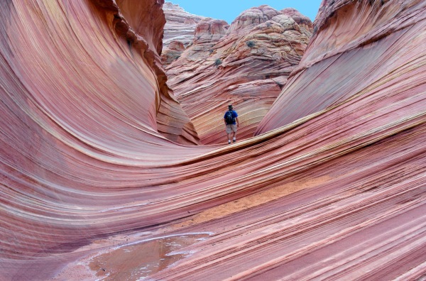
Entering The Wave, September 2003
It’s best to know what you’re getting everybody into…
Experience aside, you don’t want to lead other trusting souls on a group hike if you don’t know what to expect once you’re committed to leading it. But if you first take pains to characterize your hike so that you are reasonably satisfied with your expectations of what lies ahead, then when you publicly convey it as a bonafide hiking event, you’ll likely also attract the right people to your hike, simply because they will have reasonable expectations about the outing too.
Setting these kinds of advance expectations in your event write-up also raises the probability that you’ll keep out the riff-raff, which is to say, you’ll discourage those would-be attendees who, by seeing how you’ve characterized the hike, will likely realize they are not adequately conditioned or prepared; most will simply not show up for it. (Seasoned hike leaders will tell you: that’s a good thing.) Over time, you’ll become aware, and even thankful, that setting adequate expectations for your group will mean that your experience will be the fun outing that you planned rather than, as Dave may have experienced (and as I have too), an endurance exercise in people management.
So what kinds of expectations should you take pains to convey to your would-be group? The following list is a reasonably comprehensive one, and I consider its elements to be tantamount to crucial. So should you:
- Always list the total distance. If there’s no adequate trail description handy, grab a good map and tally up the mileage between trail junctions/waypoints. Then, double-check your math – even triple-check it.
- Always characterize the outing as a function of terrain and distance, and include seasonal factors such as weather, potential thunderstorms/flooding, and boil it down to a basic difficulty level, i.e.:
- Easy
- Moderate
- Strenuous
- Very strenuous
As an example of this, a 10-mile hiking route in late Winter can be a very different experience than hiking the same route in the heat of Summer. What may seem like a moderate hike early on can seem brutal, unforgiving, and therefore very strenuous later in the year.
- Always offer as much detail as necessary to get your hikers to the trailhead. This consideration is likely the most important one once people have committed to a hike’s distance and characterization, therefore requiring due diligence on your part so that all attendees arrive where you want them to – even when you want them to; i.e., how long they can expect to drive getting there.
- Always state when you will meet and when you will hike. Because some people will have a tendency to show up at the last minute, I usually set a 15-minute window to allow for traffic conditions and to give early arrivers adequate time to get parked and perform their pre-hike ablutions.
- If at all possible, always list an office phone number for the jurisdiction that manages the land you’ll be hiking in.
- Always provide your own phone number or some other means of quickly contacting you during the hours and minutes preceding your hiking event. It’s reasonable to share this information privately with confirmed attendees rather than post it publicly in your event.
- Optional, yet can make the difference in attendance numbers for many group hikes: a description of the expected experience, e.g., bird life, forests, grasslands, scenic views, tug-at-the-heartstrings chamber-of-commerce stuff if you prefer, plans for after the hike.
Do all of these things, and they will be the things that set a great hike leader apart from an armchair hike leader.
…so don’t be solely reliant on technology.
I’m sure it’s readily obvious from my comment to WildernessDave that I don’t place much faith in GPS technology; I surely don’t abide using a GPS system as the sole mechanism for safe and sane trail passage. I don’t believe other folks should do so, either; GPS technology is not nearly as reliable as some people tend to believe it is.
But whichever technojimcrackery you may hold in your hand, just because it’s got a microchip and software to control it doesn’t mean that it’s flawless! Don’t let technology (and its flaws) control you – or, by extension, your hiking buddies.
That’s not to say that GPS tools don’t serve a useful purpose. After all, they’re used to support land, sea, and airborne navigation, geophysical exploration, mapping and geodetic land surveys, vehicle location systems, and a wide variety of additional applications. The key take-away here is: a mobile GPS system is designed to be a support tool, not the only tool you should rely on.
————————— ♦ —————————
There are other life- and safety-critical reasons for not placing too much trust in your GPS system, as determined by researchers at Carnegie-Mellon University. To learn more, read an article titled Researchers Detect Big Flaws in GPS on the Tom’s Hardware website (a self-billed Authority on Tech).
————————— ♦ —————————
Researching my brain for a few final thoughts about…you guessed it: research.
If I may make one additional observation about setting expectations for your group hike, it is this: do your homework. And also know that placing undue faith solely in technology in lieu of adequate research one too many times will likely result in your being shunned as any kind of responsible leader by your local hiking community.
It’s a hard truth to saddle your horse with, but I’ve seen my share of this kind of bravado, and I cannot condone it. Indeed I’ve at times felt it necessary as a hike participant on another host’s event to step up and, using not much more than my wits and experience at reading unknown trail, help lead others back to where we started when confidence in the hike leader has been lost. Deciding to override the presumed authority of the hike organizer does not come easy, but when it’s a necessary decision, it’s always been the right decision in retrospect. Nevertheless, the profound outcome is that the experiences of all concerned could have been much more satisfying if the group host had been responsible in the first place. Fortunately this type of episode was not nearly the case with WildernessDave at Spur Cross; after all, his confidence in his abilities is hard-won from years of experience and experiment, virtue and volition, the tried and the true.
And: pre-hike research.
For the greater good, then, it’s better to deliver on your group’s expectations by always conducting thorough research – which, for the sagacity (and therefore, confidence) of the budding hike leader, should always mean advance trail reconnaissance – prior to even thinking about posting your group hike at that new trailhead.
————————— ♦ —————————
Have you ever organized a group hike but hadn’t first walked the trail?
Have you ever participated in a hike in which trust in the hike leader was compromised?
Please feel free to embellish upon my thoughts by adding yours.
But please, don’t judge. No group hike leader is ever a good group hike leader
until he or she makes the commitment to being one – a commitment that must renew
with each group outing.
————————— ♦ —————————
~winehiker

 Unless we’ve walked the trail together or sipped a glass or two and had a chance to let our hair down, you’ve been getting only bits and pieces of me. It’s true: I have devolved into an unabashed microblogger. Like many around us, I’ve adopted a 140-character mentality, having steadily assumed the social attention span of a mosquito, copping the latest buzz. Couple that with the regular rigors of following my hiking muse, keeping my garden green and wearing 3 hats at work, and there’s simply been little left of me for developing creative, long-tail journalism.
 Skyping across the globe in January with my friend Niki had had us both dreaming of her flying from Zurich to California toward a summer road tour of Portland, Calgary, Kalispell and Estes Park; we were going to make one big circuit of things and take 4 weeks to do it. By April, however, commitments to the road had grown less solid; a potential new hire in my department had fallen through and things had changed with Niki’s employment scenario; I was faced with the prospect of picking her up at the airport in Missoula if she could swing it. But if I could manage to escape the office at all, it was beginning to look like a solo road trip.


 were a common sight on the sunny saddle between Briones and Mott peaks.")


